
Yes, an iPhone 3D scan is sometimes enough, and you deserve to hear that even from people who make their living from laser scanning. For a volumetric sketch, a single room or the quick documentation of a plant room, the LiDAR in an iPhone Pro running Polycam or Scaniverse produces, in a few minutes, a model accurate to around a centimetre at short range, for the price of an app. But its range of roughly 5 m and the drift in its registration over larger areas set the limit: as soon as the measurement carries consequences (a tender, construction drawings, contractual areas, a BIM model), the professional laser scanner, with its millimetre accuracy and controlled registration, becomes the only defensible basis.
This article compares the three tiers of tools honestly (smartphone, virtual tour platforms, professional laser scanner) with a decision table by use. The aim is not to crown a winner: it is to put the right tool at the right moment.
Has your project already moved past the trial stage? The configurator prices your professional survey in 2 minutes.
What is the iPhone’s LiDAR (Polycam, Scaniverse) really worth?
Since the iPhone 12 Pro, Apple’s Pro models have carried a LiDAR sensor designed for photography and augmented reality. Apps such as Polycam or Scaniverse cleverly repurpose it as a 3D scanner: you sweep the room with the phone and the app reconstructs a textured mesh in real time.
What this sensor does well, it does remarkably well for the price:
- A single room is captured in two to five minutes, with dimensions good enough for a first draft.
- A volumetric sketch (understanding a volume, testing a layout idea, communicating with a client) needs nothing more.
- Quick documentation of an inspection, a cluttered cellar or a plant room before an intervention: a dated 3D record is worth more than ten photos.
- Early design: to rough out a feasibility study, an architect with an iPhone gets in one visit what used to take a sketchbook and a laser measure.
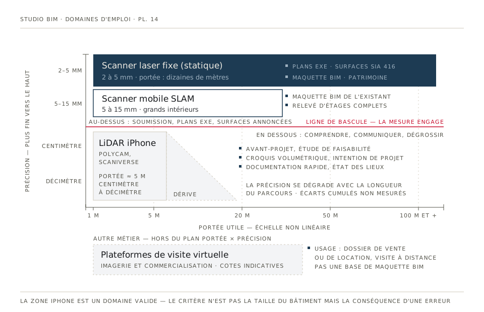
The limits are just as factual. The useful range is about 5 m: beyond that, the sensor no longer measures. Accuracy sits between a centimetre and a decimetre depending on conditions. Good at short range within one room, it degrades through drift as soon as the route gets longer: the device locates itself relative to its own measurements, and every small error adds up. Over a full floor, the accumulated discrepancies commonly reach several centimetres; two rooms scanned separately do not join up cleanly; a long corridor “tilts”. Add holes in glazed or dark areas, and the absence of any measurable quality control: the app displays a model, never an accuracy report.
The honest verdict: for sketching, documenting and communicating, yes. For measurements destined for documents that carry consequences (a tender, construction drawings, advertised areas), no, and that is not what the tool was designed for.
Do virtual tour platforms really measure?
Between the smartphone and the professional scanner, a third player occupies the ground: virtual tour platforms (Matterport is the best-known reference). A 360° camera on a tripod, stitched panoramas, a tour you can navigate online with a built-in measuring tool.
We should be precise about what this is: an imaging and marketing tool, not a construction measurement tool. The virtual tour excels at showing a property remotely, cutting pointless viewings and enhancing a listing; we cover this in 3D surveys and property sales. The dimensions you take from it will do for a rough order of magnitude; they replace neither an architect’s drawing nor a schedule of areas. The file it produces is meant to be viewed in a browser, not imported into Revit or Archicad as a reliable basis for modelling.
Ordering a virtual tour in the belief that you are buying a survey is the most common mistake we see among property management firms: the deliverable is seductive, but the day the architect asks for the point cloud for a conversion project, there is nothing usable behind it.
The professional laser scanner: what the price actually buys
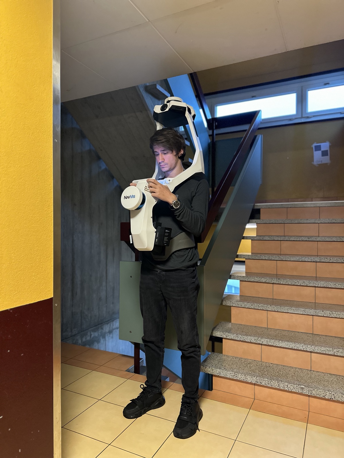
A professional survey relies on two families of instruments, detailed in our guide to 3D building scanning: the terrestrial laser scanner on a tripod (accuracy of around 2 to 5 mm, range of several tens of metres) and the SLAM mobile scanner worn by the operator (5 to 15 mm, maximum productivity indoors). On paper, the gap with the iPhone looks like a matter of millimetres. In reality, the sensor is only the beginning.
What sets a professional survey apart from an app scan is the process around the measurement:
- Controlled registration. The dozens of stations or trajectories are assembled into a single cloud using targets and overlap zones, with a quantified check of the registration residuals. The drift that condemns an iPhone scan over a whole floor is here measured, corrected and documented. This is the heart of the trade, and we devote a whole article to it: the building point cloud.
- Georeferencing. The cloud can be tied to the Swiss reference frame (MN95/LN02), a prerequisite for working with the cadastre, a land surveyor’s plan or a building permit application.
- Open, usable deliverables. A cleaned and structured E57 cloud, DWG drawings, a Revit/Archicad/IFC model: files that your practice or your consultants use directly.
- Professional liability. A provider signs its survey, documents its accuracy and answers for it. When a tender or lettable areas rely on the data, someone has to be accountable for it; a consumer app is not.
The same logic applies to swisstopo’s public LiDAR data, excellent for its territorial purpose but not designed for buildings: we set it out in Swiss public LiDAR vs dedicated scan. The question is never “does the data exist?” but “was it produced and checked for your use?”.
On budget, transparency is our choice: a professional scan on its own (delivery of the point cloud) starts at CHF 610, a full survey with a LOD 300 BIM model at CHF 1’350, with the exact figure in 2 minutes in the configurator.
Which tool for which use? The decision table
| Use | iPhone LiDAR (Polycam, etc.) | Virtual tour | Professional laser scanner |
|---|---|---|---|
| Volumetric sketch, design intent | Enough | Not relevant | Overkill |
| Early design, feasibility study | Often enough (single rooms, volumes) | Visual complement | Useful if the project goes ahead |
| Quick documentation (inspection, plant room) | Enough | Possible | Overkill |
| Sales or letting file | Insufficient (rendering) | Suitable (marketing) | Suitable if drawings and areas are required |
| Construction drawings | No | No | Essential |
| As-built BIM model | No (unreliable basis) | No | Essential |
| Contractual areas (SIA 416) | No | No | Essential |
| Heritage, complex structures | No | Visual complement | Essential |
The dividing line is simple: as long as the data serves to understand and communicate, the smartphone or the virtual tour does the job, quickly and for next to nothing. As soon as the data serves to build, contract or price, millimetre accuracy, controlled registration and traceability become the condition of defensible work. For an architecture practice, the two worlds actually combine very well: iPhone in the pocket for the first visit, professional survey ordered the moment the commission is confirmed.
Frequently asked questions
Is the iPhone’s LiDAR accurate enough for drawings?
For an intent drawing or a layout diagram, yes. For architect’s drawings intended for a building permit application, a tender or construction, no: accuracy of a centimetre to a decimetre and registration drift across sequences of rooms produce discrepancies incompatible with construction dimensions, with no way of quantifying them.
Can you build a BIM model from a Polycam scan?
Technically you can model on any basis; the question is what the model is worth. A BIM model inherits the quality of its input data: built on a scan with uncontrolled drift, it reproduces the scan’s errors with the appearance of rigour. For a model intended for a real project, the basis remains a professional point cloud, registered and documented.
What is the difference between a virtual tour and a 3D survey?
The virtual tour is an imaging product: stitched photo panoramas for navigating through a property, with indicative measurements. The 3D survey is a measurement product: a controlled point cloud from which drawings, areas and a BIM model are extracted. One sells a property, the other lets you transform it; both can coexist on the same project.
When does a professional scan become essential?
As soon as the data commits you to something: a contractor’s tender, construction drawings, lettable or sales areas, a project BIM model, a heritage file. The criterion is not the size of the building but the consequence of an error: if a 5 cm discrepancy on a wall costs francs or ends in a dispute, a professional survey is no longer optional.
The right tool at the right moment. Keep Polycam for the sketches; when accuracy carries consequences, price your professional survey in 2 minutes: studiobim.ch/devis.