
Switzerland has some of the best public LiDAR data in the world, and it is free. For the context of your plot, the terrain and the roofs, swissSURFACE3D is often enough. For the building itself (accurate façades, interiors, a BIM model at LOD 200 and above) you need a dedicated scan: the public data is roughly a thousand times less dense than what a usable model requires.
It is a question we hear regularly from building owners in French-speaking Switzerland: “the data already exists, doesn’t it?” The honest answer: yes and no. This article sets out what Swiss public LiDAR covers, where it stops, and how to decide, including when a third party has already handed you a point cloud.
What Swiss public LiDAR covers
swisstopo publishes, as open data (Open Government Data, since 2021), several products derived from airborne LiDAR campaigns:
- swissSURFACE3D: the raw classified point cloud (ground, vegetation, buildings, water, bridges), delivered as LAS/LAZ tiles. Minimum density of 5 pts/m² (15 to 20 pts/m² on average; the update under way targets a minimum of 15 pts/m²), accuracy of ±20 cm in plan and ±10 cm in height (1 sigma values).
- swissALTI3D: the derived digital terrain model, on a 0.5 m grid.
- swissBUILDINGS3D 3.0: building volumes with roof shapes, derived from the LiDAR.
The first national survey is complete and swisstopo plans an update in six stages between 2024 and 2029, that is a cycle of roughly 6 years per region. Some cantons also publish their own campaigns, denser or more recent: in Geneva, the SITG’s 2023 cantonal LiDAR survey reaches a minimum density of 100 pts/m²; in the canton of Vaud, the published data (2018–2019 campaigns) comes from the federal programme, to the same specifications.
In practice, this data already allows a great deal:
- Site context: placing your project in its real surroundings (terrain, neighbouring buildings, vegetation) for a feasibility study or a rendering for a permit application.
- Roofs: geometry and orientation of the roof planes, the basis of tools such as toitsolaire.ch for solar potential.
- Terrain: contour lines, profiles, earthworks volumes at preliminary design stage.
- LOD 100 neighbourhood model: accurate volumes for working on the siting.
All of it can be downloaded free of charge from map.geo.admin.ch. If your need stops there, you do not need us, and that is perfectly fine.
Where public LiDAR stops: the building itself
Airborne LiDAR looks at the territory from the sky. Three direct consequences:
- No interiors. The beam does not pass through roofs. For floor plans, SIA 416 areas, a renovation model: nothing.
- Façades almost entirely missing. Seen from the sky, façades are at a grazing angle: a few scattered points, no window reveals, no thicknesses, no ornaments. No reliable elevation can be drawn from them.
- Density too low for BIM. At ~5 pts/m² and ±10–20 cm accuracy, you are three orders of magnitude below what a LOD 200 or higher model requires: a terrestrial scanner such as the RTC360 produces tens of thousands of points per m² locally, with millimetre-to-centimetre accuracy. Modelling a wall to ±20 cm means not knowing whether it is 15 or 45 cm thick.
In short: public LiDAR describes the envelope of the territory, not the building as an object. As soon as your deliverable is a Revit or Archicad model of the existing building, dimensioned plans, sections and elevations, or a floor area table, the data has to be acquired on site. Our guide 3D scanning a building: technologies, accuracy, uses covers the technologies (static scanning, mobile scanning, photogrammetry) and their respective accuracies.
The same logic for a point cloud that “already exists”
A frequent variant: “a provider has already scanned it, here is the E57 file”. Potentially good news: an existing point cloud of good quality avoids paying for the acquisition twice. But before starting any modelling, we systematically audit it against four criteria:
- Density: are there enough points everywhere, including at height, in corners and in plant rooms? A cloud that is dense on the ground floor and starved in the attic does not allow a consistent LOD.
- Coverage: is every zone seen from several stations? Shadow zones (behind a piece of furniture, under a staircase) become modelling assumptions, and therefore risks.
- Noise: ghost points, reflections on glazing, surfaces several centimetres “thick”. A noisy cloud leaves the modeller guessing at the real position of every wall.
- Registration: are the stations assembled cleanly? Doubled walls or floors that step like a staircase betray a failed registration, and no amount of modelling can fix that.
A real case: a client asked us to turn an existing E57 of an agricultural building in Vaud into Archicad files. Our analysis concluded that the quality of the cloud was insufficient for proper use. We declined to model on it and recommended a full survey. The survey was redone, and the Archicad model delivered with its BIMx model. Modelling on a poor cloud would have cost less on the quote and far more at the first clash on site.
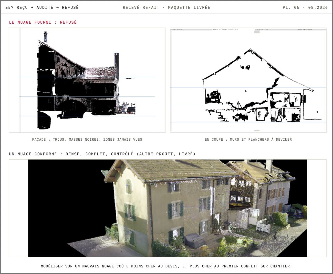
If someone supplies you with a point cloud, send it to us before placing any order: the audit is part of the scoping work, as described in our standard specification for ordering a 3D survey.
The decision tree
| Your need | swisstopo public data | Existing cloud (third party) | Dedicated scan |
|---|---|---|---|
| Site context, LOD 100 neighbourhood model | Yes | n/a | Unnecessary |
| Solar study, roof geometry | Yes (toitsolaire.ch) | n/a | Rarely |
| Terrain, earthworks at preliminary design | Yes (swissALTI3D) | n/a | If tolerance < 10 cm |
| Dimensioned façades, elevations | No | If the audit passes | Yes |
| Floor plans, SIA 416 areas | No | If the audit passes | Yes |
| LOD 200+ BIM model of the existing building | No | If the audit passes | Yes |
Three questions are enough in practice:
- Does the deliverable concern the territory or the building? Territory → start with swisstopo, it is free.
- Does a point cloud already exist? Yes → audit density / coverage / noise / registration before any decision.
- Otherwise → a dedicated scan, sized for the target LOD and the expected deliverables. The two combine very well, incidentally: a dedicated scan for the building, swissSURFACE3D to set the model in its context.
FAQ
Is swisstopo LiDAR data really free? Yes. Since 2021, swissSURFACE3D, swissALTI3D and most federal geodata have been open access (download from map.geo.admin.ch), and can also be used commercially under the OGD terms.
Can I prepare my permit application with public data alone? For the context (terrain, neighbours, building envelopes), often yes. For the building being converted itself, you need an accurate survey of the existing structure: the airborne data provides neither interiors nor reliable façades.
Can a BIM model be produced from swissSURFACE3D? A LOD 100 massing of the neighbourhood, yes. A LOD 200+ model of the building, no: density and accuracy fall short by a factor of roughly a thousand.
I have been given an E57 file: how do I know whether it is usable? Four criteria: density, coverage, noise, registration. Send us the file: we audit it before pricing, and we will tell you honestly whether it holds up or whether it needs rescanning. We have already had to reject a cloud and recommend a full survey.
How much does a dedicated scan cost? It depends on the floor area, the product (scan only or scan + model) and the level of detail. The ranges for French-speaking Switzerland are detailed in our article How much does a 3D survey cost in French-speaking Switzerland?, or get a price for your building directly.
Does your project need more than the public data? Configure your survey (floor area, deliverables, level of detail) and receive a quote in 2 minutes: studiobim.ch/devis. To understand exactly what a dedicated scan produces, see also our Scan only page.