
An architectural survey means measuring an existing building in order to produce reliable drawings: floor plans, sections, elevations, or a BIM model. Two main methods compete: the traditional manual survey (laser measure, dimensioned sketch), quick to mobilise and sufficient for a small, regular floor area, and 3D laser scanning, exhaustive and re-measurable at will, which becomes the obvious choice as soon as the geometry gets complicated. The right choice depends on three variables: the floor area, the complexity of the building, and what you will have to prove or draw afterwards.
This article is a decision grid, not a sales pitch. We make our living from 3D scanning, and we are going to start by telling you when you do not need it.
Already know which method you need? The configurator prices your survey in 2 minutes, based on floor area and deliverables.
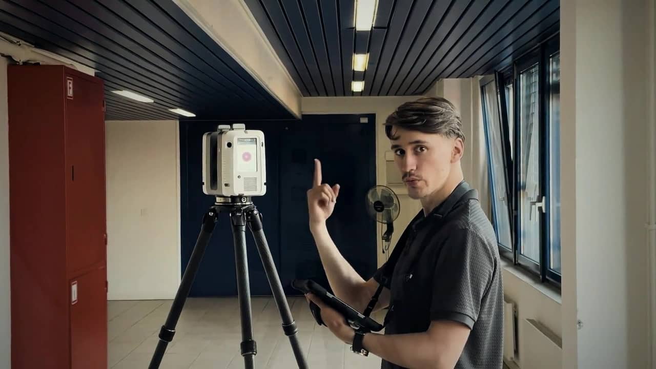
Why survey the existing building again? Aren’t the archive drawings enough?
Because they lie, almost systematically. Across the building stock of French-speaking Switzerland built before the 1990s, a gap between archive drawings and the actual building is the rule: partitions moved without the drawings being updated, attics converted, ducts added, dimensions corrected by hand on paper prints. Starting a preliminary design from those drawings means drawing on a fiction, and discovering reality during demolition, when every surprise costs money. We have documented this risk, with figures, in a dedicated article: outdated archive drawings: the hidden risk in your renovation.
So the question is not “do we need a survey?” but “which one?”. For an architecture practice, it is a trade-off between mobilisation time, accuracy, completeness and budget. Let us review the methods.
The traditional survey with a laser measure: when is it enough?
A manual survey means the architect or a member of staff on site with a laser distance meter, a sketchbook and a method: freehand sketch of each room, main dimensions taken (lengths, widths, ceiling heights, piers, reveals), triangulation of non-rectangular rooms, then a fair copy in DWG back at the office.
It is enough, and it remains the right choice, in specific cases:
- a studio or small flat with a regular geometry: square walls, a single level, no visible deformation. Half a day on site, the fair copy, and the plan is done;
- a simple condition record or a marketing plan, with no conversion project behind it: the acceptable tolerance is wide;
- a very localised intervention (replacing a kitchen, opening a door in a lightweight partition) where only a few dimensions matter.
In these situations, mobilising a laser scanner would be disproportionate. Saying so seems more useful to us than selling scanning everywhere.
It becomes patchy as soon as the geometry gets complicated. Three warning signs, drawn from buildings we survey every week:
- walls out of plumb: an old wall leans, and a distance meter aimed at chest height will never see it. The dimension is right, the wall is wrong;
- non-parallel walls: without systematic triangulation of every room (long, tedious, rarely complete), the plan “straightens” angles that do not exist. Errors accumulate from room to room, and the envelope no longer closes;
- levels that do not line up: offset slabs, half-levels, floors that have sagged. Done manually, making three separately surveyed storeys coincide is a gamble.
Add to that the structural limit of the method: you only bring back from site what you thought to measure. The forgotten dimension (there is always one) costs a return trip. And a manual survey leaves few traces: in a dispute over the condition before works, a sketchbook carries little weight.
3D laser scanning: exhaustive, documented, re-measurable
Laser scanning captures millions of points on every visible surface (walls, slabs, ceilings, exposed services) and produces a point cloud: a measurable, dated digital copy of the building. Two families of instruments share the work:
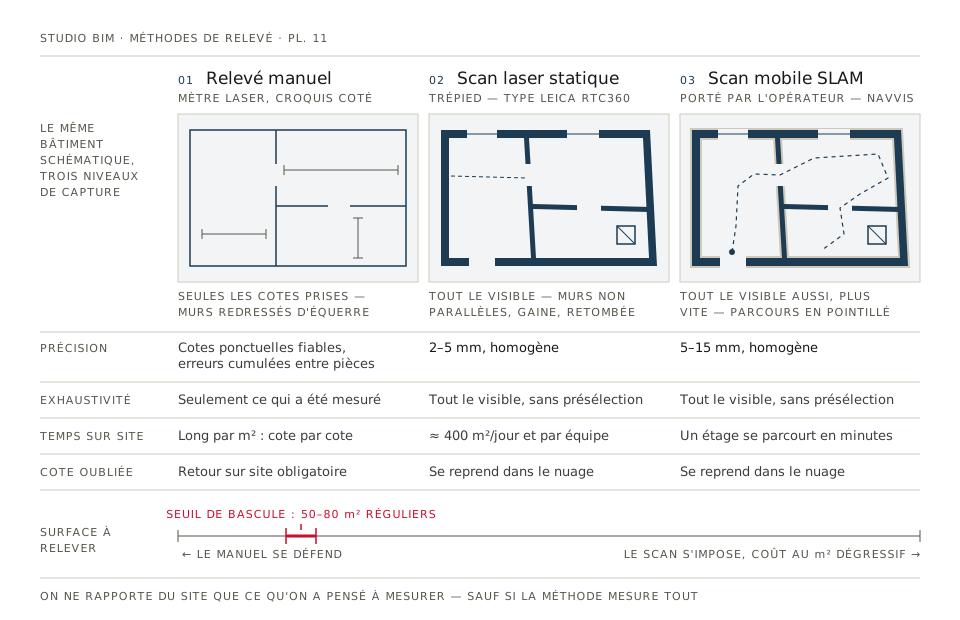
- the static tripod-mounted scanner (Leica RTC360 type): accuracy in the region of 2 to 5 mm, the reference for deformed structures, heritage buildings and demanding geometries;
- the mobile SLAM scanner (NavVis type, carried by the operator): accuracy in the region of 5 to 15 mm, but unmatched productivity in partitioned interiors; a whole floor is walked in minutes.
The two are combined on a single survey: accuracy where it matters, speed everywhere else. The details of the technologies, the protocol (registration, MN95 georeferencing) and the delivery formats are covered in our guide to 3D building scanning.
What scanning changes compared with manual surveying comes down to three words:
- exhaustive: everything visible is measured, with no preselection. Walls out of plumb, non-parallel walls and level offsets are in the data, not smoothed away by the method;
- documented: the point cloud is a dated, verifiable record of the existing condition, a useful reference in any before/after dispute;
- re-measurable: the forgotten dimension is taken from the point cloud, at the office, six months later. You go back to site “virtually” as often as you like, without disturbing the occupants again.
The deliverables are then extracted from the point cloud: 2D drawings (DWG/PDF), or a Revit/Archicad BIM model built on the real geometry (LOD 300 as standard). That is our survey + BIM modelling service.
What about drone photogrammetry?
The drone complements ground-based scanning more than it replaces it. Photogrammetry reconstructs 3D geometry from overlapping photographs, with an accuracy in the region of 1 to 3 cm: sufficient for roofs, tall façades, chimneys and inner courtyards (everything the scanner cannot see from the ground), but insufficient for the interior of a renovation. For a façade survey or a roof file, it is the economical method; indoors, it is not in the same league. The weather and the regulatory framework for flights in Switzerland also have to be factored into the preparation.
Traditional survey vs 3D scanning: the comparison table
| Criterion | Traditional manual survey | 3D laser scanning |
|---|---|---|
| Time on site | Long per m²: each dimension is taken one at a time | Short: in the region of 400 m² per day and per team |
| Accuracy | Reliable individual dimensions, but errors accumulate between rooms and levels | 2–5 mm (static), 5–15 mm (mobile), consistent across the whole building |
| Completeness | Only what was measured on site | Everything visible, with no preselection |
| Irregular geometries | Out-of-plumb and non-parallel walls invisible or “straightened” | Captured as they are in the point cloud |
| Relative cost | Low on a small, simple floor area; rises quickly with complexity | Decreases with floor area; disproportionate below 50–80 m² of regular space |
| Deliverables | Fair-copy 2D drawings | Point cloud (E57), 2D drawings, Revit/Archicad BIM model, orthophotos |
| Re-measurability | None: forgotten dimension = return to site | Total: any dimension can be taken again from the point cloud, at any time |
| Documentary value | Low (sketchbook) | High: dated, verifiable, archivable record |
How to choose: the four-question grid
- What floor area? Below 50–80 m² of regular space, manual surveying holds up. Above that, time in the field and cumulative errors tip the balance towards scanning, all the more so because its cost per m² decreases with area.
- What geometry? Old building, deformed walls, half-levels, exposed roof structure: scanning, no hesitation. Recent, square open-plan floor: manual may be enough.
- What project follows? A condition record tolerates approximation; a major conversion, the addition of storeys or a building permit application demand an accurate base, and often a BIM model.
- Will you need to come back to it? If the project stretches out over time, if several parties will need different dimensions, the re-measurability of the point cloud pays for the survey on its own.
What to ask for in a survey quote
Whether you consult Studio BIM or another provider, a serious survey quote must state in black and white:
- the exact scope: which rooms, which levels, exteriors and roofs included or not;
- the technology or technologies used, and the expected accuracy: not “high precision” without a figure;
- the deliverables and their formats: E57 point cloud every time (it is your raw data, insist on it), DWG/PDF for drawings, native Revit or Archicad format plus IFC for a model, with the level of detail (LOD) in writing;
- the coordinate system: local, or georeferenced MN95/LN02 if the survey has to communicate with the land register or a land surveyor;
- the lead time, and what happens if an area is inaccessible on the day;
- the price and the logic behind it. Price transparency is possible: our rate card is public and our configurator gives the figure in 2 minutes. To get a sense of market orders of magnitude in French-speaking Switzerland, see how much does a 3D survey cost in French-speaking Switzerland.
Frequently asked questions
What is an architectural survey?
It is the measurement of an existing building and its rendering as usable documents: floor plans, sections, elevations, or a BIM model. It serves as the basis for any project on an existing building (renovation, conversion, building permit application, sale) and is carried out manually (laser measure, sketches) or by 3D laser scanning depending on the size and complexity of the building.
What accuracy can you expect from an as-built survey?
A static laser scanner reaches 2 to 5 mm, a mobile scanner 5 to 15 mm, drone photogrammetry 1 to 3 cm. A manual survey produces reliable individual dimensions but an overall accuracy that is hard to guarantee, as errors accumulate between rooms and between levels. For a BIM model, the final accuracy also depends on the agreed modelling tolerances.
How much does an architectural survey cost in French-speaking Switzerland?
For a 3D survey with BIM model, expect in the region of CHF 3 to 11 per m² depending on floor area (the rate decreases with area), with a minimum order of CHF 1’350. Examples: around CHF 2’250 for a 200 m² detached house, around CHF 5’350 for 850 m². Scanning alone (point cloud delivered) starts at CHF 610. Your exact figure: configurator in 2 minutes.
Does 3D scanning replace the architect?
No. Scanning replaces the tape measure, not the eye. It delivers exhaustive, accurate data; it is the architect who interprets it, decides what matters for the project and turns it to constructive advantage. A good 3D survey saves the architect the days in the field and the return trips to site, not their added value.
Which deliverables should you ask for in a survey?
At minimum, the point cloud in E57 (open standard) with the coordinate system stated, and the 2D drawings in DWG and PDF. For a BIM model: the native format (RVT or PLN) plus IFC, with the LOD written into the contract; our standard deliverable is LOD 300. Refuse any “visualisation only” deliverable from which you could extract nothing.
The right method, at the right price, in black and white. Describe your building and get a figure in 2 minutes: studiobim.ch/devis.