
A building’s archive drawings describe, at best, a former state and, at worst, a project that was never built as drawn: moved partitions, added ducts, suspended ceilings and converted attics almost never appear on them. Starting a conversion from those drawings means pricing wrong quantities, designing in a geometry that does not exist and discovering the real building mid-construction, at the cost of change orders, stoppages and sometimes disputes. The remedy is simple: check the existing building before you draw, with a 3D survey that records its real condition, exhaustively and with a date.
This article explains why drawings lie, what those lies cost, what a survey changes in practice and, honestly, in which cases the archives are enough after all.
Is your project starting from drawings nobody has checked in decades? The configurator prices your 3D survey in 2 minutes.
Why are archive drawings wrong?
Four mechanisms add up. None of them is a matter of exceptional negligence: it is the normal life cycle of a building that has never been redocumented.
The original state is not the as-built state
The drawings kept in municipal archives or by the owner are most often those of the building permit application: a project, not a record. Between the permit and handover, the site made its own decisions: a downpipe moved, a wall thickened, a window dropped. Unless as-built drawings were produced and then archived (rare before the 1990s, patchy since), the document you are looking at describes an intention, not the building.
Successive alterations never make it back onto the drawings
A refitted kitchen, an added bathroom, a converted loft, a suspended ceiling installed to hide a ventilation duct: most of these works are done without an architect, sometimes without a permit, and almost always without updating the drawings. Add up forty years of small interventions and the archive document describes a building that no longer exists, floor by floor, room by room.
Theoretical dimensions were never checked
Even when the overall geometry is right, the dimensions are those of the drawing, not of the construction. A wall that is “vertical” on the drawing leans by several centimetres over its height; a “level” floor has sagged; two “parallel” walls converge. In older buildings, 90° corners and constant thicknesses are the exception. These deviations are invisible on a paper print, and decisive as soon as a made-to-measure element, a lift shaft or a level junction is planned.
The medium itself has degraded the information
Folded tracings, diazo prints shrunk by humidity, photocopies of photocopies, scans at an approximate scale: measuring with a scale rule on an archive drawing adds a reproduction error to the drawing error. A dimension scaled off a distorted print can differ noticeably from reality without anything flagging it.
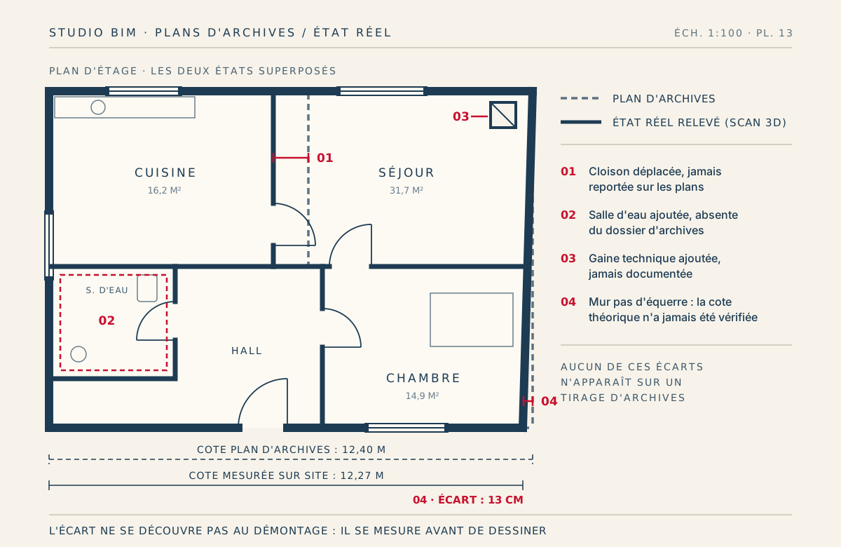
Two scenarios we see regularly
The 1960s house in Geneva
The archive file: four tracings from 1963, legible, appealing. The real building: a conservatory added in the 1980s that appears nowhere, a re-partitioned basement, a chimney sealed off but still drawn, and ceiling heights that vary by several centimetres from one room to the next where the drawing shows a single dimension. The architect who designs the conversion on those tracings is designing a house next door to the real one, and every discrepancy will resurface at the most expensive moment to correct it: during construction.
The managed apartment building and its fifty years of small alterations
A 1970s rental building: at each change of tenant, a refitted kitchen, a moved partition, a modified plumbing stack. None of these interventions was ever transferred onto the drawings held by the property management firm, which date from construction. The result: advertised lettable areas that no longer match the real areas, drawings unusable for a maintenance tender, and a real risk at the time of a sale, a subject we cover in detail in 3D surveys and property sales: a wrongly advertised area can turn into a dispute with the buyer.
What wrong drawings really cost
No claims statistics are needed to describe the mechanism; anyone who has lived through a conversion project knows it. Three chains of consequences:
Wrong quantities → distorted tenders → change orders. Tender quantities are taken off the drawings. If wall, floor or façade areas are wrong by a few per cent, every bid is wrong too, and the difference is settled through change orders, negotiated after the contract is awarded, that is, at the moment the client has the least leverage.
Technical elements discovered during construction → stoppages. An undocumented duct where the future lift is to go, a supposedly non-load-bearing wall that turns out to be load-bearing, a slab thinner than expected: each discovery means stopping, bringing the engineer back, redrawing and sometimes retendering. The direct cost can be quantified; the cost of the delayed programme (rent, rehousing, penalties) comes on top.
Wrongly advertised areas → disputes. A lease or a deed of sale stating an incorrect area can engage the liability of its signatory. On a rental building, the gap between advertised and measured areas feeds through to the rent roll; on a sale, it can ground a challenge to the price.
In all three cases, the common thread: the error was bought at the moment it was cheapest to correct, on paper, before the first line was drawn, and paid for at the moment it costs the most, on site.
What a 3D survey changes
A 3D laser scanning survey does not “update” the archive drawings: it replaces them with a record of fact. The difference comes down to four properties:
| Archive drawings | 3D survey | |
|---|---|---|
| What is described | A project or a former state | The as-built condition, as it stands |
| Completeness | The dimensions the draughtsman chose | Everything visible, without preselection |
| Accuracy | Theoretical, never checked | 2 to 15 mm depending on the technology |
| Date | Often unknown or misleading | Dated to the day of acquisition |
| Consultation | What is drawn, nothing more | Unlimited “site visits” from the office |
The last line is the one that changes a project’s daily routine: the point cloud can be consulted throughout the design stages. A forgotten dimension, a doubt about a downstand beam, a headroom check: you open the cloud at the office instead of scheduling another visit. And when the survey includes a BIM model (our standard deliverable: LOD 300, Revit or ArchiCAD), the architect designs the project directly within the real existing building: the quantities taken off the model are those of the building, not of a 1963 tracing.
To place the 3D survey against a manual survey with a laser distance meter, which remains relevant for very small scopes, see our comparison Traditional architectural survey vs 3D scanning.
One last point, often underestimated: a 3D survey is a documented, dated and verifiable record of the existing condition, produced by a third party: a useful pre-works reference in the event of a dispute with a contractor, or in a condominium to document a condition before an intervention.
When are archive drawings enough after all?
Let us be honest: not every project justifies a survey. Archive drawings can be enough when the following three conditions are all met:
- No intervention on the structure or the areas: refreshing paint and floor finishes, like-for-like replacement of fittings, routine maintenance.
- No made-to-measure element whose dimensions depend on precise measurements (joinery, glazed roof, staircase, lift).
- No contractual or official document will rely on those drawings: no building permit application, no areas stated in a lease or a deed.
As soon as one of these conditions falls away (you touch a wall, you state an area, you order something made to measure), the question is no longer “should we check?” but “what does checking cost compared with the risk?”. Order of magnitude: a full survey with a BIM model starts at CHF 1’350 and sits between CHF 3 and 11/m² depending on floor area (decreasing); the detail of the price factors is in How much does a 3D survey cost in French-speaking Switzerland? Compare that with the cost of a single change order or a week’s stoppage on site.
Frequently asked questions
Why are archive drawings so often wrong?
Because they rarely describe the as-built condition: they are most often building permit drawings (a project, not a record), never updated after changes on site or after successive alterations: partitions, ducts, suspended ceilings, converted attics. Add theoretical dimensions never checked on a building that is neither square nor plumb, and paper media distorted by time.
How can I check whether drawings are up to date?
A quick check on site is enough to form an opinion: compare a few dimensions measured with a laser distance meter against the drawing (room lengths, wall thicknesses, heights), check the position of partitions and services in two or three rooms, and look for the date and nature of the document (permit or as-built?). If discrepancies appear in this sample alone, the rest of the drawing is no more reliable, and a full survey is required before any design work.
What if a building has no drawings at all?
It is a common case, and paradoxically healthier than a wrong drawing, because nobody is tempted to trust it. A 3D survey rebuilds the complete file from scratch: point cloud, floor plans, sections, elevations, and a BIM model if the project justifies it. The building does not need to be empty, nor do the works need to be decided: the survey also stands on its own as heritage documentation.
Is a 3D survey worth it for a small renovation?
It depends on what you touch, not on the size. For a refresh with no intervention on the structure or the areas, no: the existing drawings or a few manual measurements are enough. As soon as structure, stated areas or made-to-measure work are involved, the calculation changes: a 200 m² detached house is surveyed and modelled for CHF 2’250, to be set against a single site surprise discovered too late.
Checking before drawing costs less than discovering on site. Price the 3D survey of your building in 2 minutes: studiobim.ch/devis.