
HBIM (Heritage BIM) means applying 3D laser scanning and BIM modelling to old, historic or listed buildings. In this kind of building, nothing is straight, nothing repeats and every element is unique: a tape-measure survey quickly reaches its limits, whereas the scanner captures irregular geometry to the millimetre, without touching the fabric. The resulting point cloud then does double duty: the basis of the model today, and a dated, complete archive of the building for decades to come.
It is probably the case where a 3D survey is both the most cost-effective and the least replaceable. This article explains why, what modelling an old building forces you to decide, and what an HBIM survey actually delivers.
Preparing works on an old building? The configurator prices your survey in 2 minutes, based on floor area and deliverables.
What is HBIM?
The term refers to scan-to-BIM applied to historic buildings: acquisition of a point cloud by laser scanner, then modelling of a Revit or ArchiCAD model on that cloud. The technical workflow is the same as for a 1980s apartment block; what changes is the building.
An old building combines three characteristics that weigh on the survey:
- Nothing is straight. Battered (leaning) walls, floors that have sagged, corners that are not 90°, levels that vary from one room to the next.
- Nothing repeats. No grid, no typical floor to duplicate: every bay, every opening, every roof truss has its own geometry.
- Every element is unique. A rubble stone wall has no nominal thickness; a vault is not a catalogue arch. The element is measured, not inferred.
These three characteristics defeat the methods designed for regular buildings: standard plans, assumptions of orthogonality, extrapolation from one floor to the next. They also make laser scanning the natural tool for surveying a historic building.
Why scan rather than measure by hand?
Geometry a tape measure cannot capture
A traditional survey with a laser distance meter presupposes exactly what old buildings contradict: flat walls, right angles, regular elements between two measured points. A groin vault, an 18th-century roof structure, a rubble wall whose thickness varies from 55 to 80 cm along its length: no series of spot dimensions can reproduce that geometry. The scanner, by contrast, measures millions of points without preselection: the deformation is in the data, not in the operator’s interpretation. We covered this comparison in detail in traditional survey vs 3D scanning.
No contact with the fabric
On a listed object, every physical intervention counts. The laser scanner measures at a distance: a weakened roof structure, a painted ceiling, an old render are all surveyed from the ground, with no ladder leaning against the masonry and no hand on the decoration. Long-range scanners document a vault, a tower or a tall façade without scaffolding, which is often the most visible saving on the project, before accuracy is even mentioned. For roofs and inaccessible elevations, drone photogrammetry completes the set-up, again without contact.
The point cloud as an archive
A point cloud is a dated, complete and measurable record of the building. Unlike a drawing, which contains only what its author chose to put in it, the cloud contains everything the scanner saw, including what nobody needs today. Ten years later, you go back “virtually”: take a dimension, check the condition of a cornice at a given date, compare before and after a settlement.
This documentary value becomes an insurance value in the event of a disaster. The best-known example is Notre-Dame de Paris: the laser scans carried out before the 2019 fire served as the geometric reference for the reconstruction. At the scale of a building in French-speaking Switzerland, the principle is the same: documenting before works means having a documented, dated and verifiable reference if damage occurs during the site works, and a basis for restoration if the worst happens.
What do the cantonal heritage services require?
In substance, the requirement is the same from one canton to the next: before authorising works on a listed or inventoried object, the heritage services require rigorous documentation of the existing condition. In the canton of Vaud, applications for works on protected buildings and sites go through the Direction générale des immeubles et du patrimoine (monuments and sites division); in Geneva, through the Office du patrimoine et des sites. The exact procedures vary with the canton, the inventory grade and the nature of the works; the useful reflex is to consult the competent service at sketch stage, not when the file is submitted.
A 3D survey meets this requirement with room to spare: rather than a minimal set of drawings, it produces a complete, verifiable record from which the required documents are then extracted: plans, sections, façade elevations dimensioned on the real geometry. For municipalities and institutions that own a historic estate, it is also the foundation of lasting heritage documentation; we devote a dedicated page to it: heritage and public authorities.
How far should an old building be modelled?
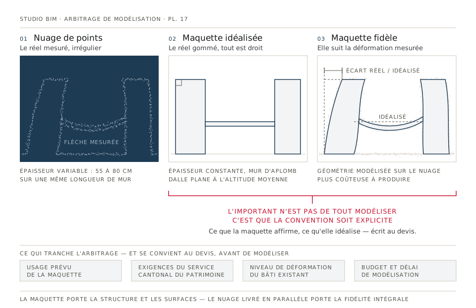
This is the real difficulty of HBIM, and it is decided before modelling, not after. A BIM model idealises by construction: a wall has a thickness, a slab is flat. On an old building, every gap between reality and the model is a choice to own and to document.
| Historic element | The question to settle | Common practice |
|---|---|---|
| Battered (leaning) wall | Reproduce the lean or idealise as vertical? | Documented idealisation within an agreed tolerance; faithful modelling beyond it |
| Deformed floor | Flat slab or deformed surface? | Flat slab at mean level, deflections annotated in the model |
| Vaults, roof structures | Library elements or surveyed geometry? | Modelled in place on the cloud, element by element |
| Mouldings, decoration | Model in fine detail or refer to the cloud? | Cloud linked to the model as a reference, fine reproduction on request |
The level of geometric detail is agreed at quote stage, as for any scan-to-BIM: our standard deliverable is LOD 300, with the point cloud always delivered alongside; the model carries the structure and the areas, the cloud carries full fidelity. To see what each level covers, see LOD 100–400: which level of detail? What matters is not modelling everything: it is that the convention is explicit, so that the architect or the conservator knows what the model asserts and what it idealises.
The case of a barn in the canton of Vaud
A real example from our practice, told in detail in our point cloud guide: the E57 file of a Vaud barn, surveyed by a third party, turned out to be unusable on audit, with patchy overlap between stations and entire areas missing. The whole building had to be rescanned before any modelling could start.
Two lessons. First, a point cloud is not usable simply because it exists: on an old building, where every element is unique, a missing area cannot be reconstructed by symmetry or repetition. Second, always require the E57 and have it audited before commissioning any modelling on it.
What an HBIM survey from Studio BIM includes
Our 3D survey + BIM modelling service, applied to historic buildings, delivers:
- the complete point cloud, cleaned and structured (E57, RCP on request), with documented coordinate system and acquisition date: your archive;
- the BIM model in Revit or ArchiCAD, modelled on the cloud according to the conventions agreed together (LOD 300 as standard), plus IFC for exchange;
- the plans, sections and façade elevations (DWG, PDF) extracted from the model and dimensioned on the real geometry: the documents expected in an application for works on a listed object.
The building does not need to be empty, and the type of building does not change the price: our rate card applies no “heritage” surcharge; the price follows the floor area and the chosen deliverables.
Frequently asked questions
What is HBIM?
HBIM stands for Heritage (or Historic) Building Information Modelling: the application of 3D laser scanning and BIM modelling to old, historic or listed buildings. The technical workflow is that of conventional scan-to-BIM; the difference lies in the irregular geometry of old buildings and the modelling conventions it imposes.
Can a listed building be scanned without touching it?
Yes, and it is one of the main arguments for laser scanning on heritage: measurement is done at a distance, without contact with the fabric. Vaults, painted ceilings and tall façades are surveyed from the ground or by drone, with no scaffolding and no ladder against the masonry.
What level of detail for a historic building?
Our standard deliverable is LOD 300, which covers most renovation projects and applications for works. What counts more than the number is the fidelity convention: how far the model reproduces deformations, and from what point it refers to the point cloud, which is always delivered alongside.
Does the point cloud serve as an archive?
Yes. The cloud is a dated, complete and measurable record of the building, which can be consulted years later without a new visit. It is a documentary reference before works and a basis for restoration in the event of a disaster: an insurance value that on its own justifies documenting a listed object.
How much does surveying an old building cost?
The same as a recent building of equivalent floor area: our rate card applies no surcharge by building type. A survey + BIM model starts at CHF 1’350; as reference points, allow around CHF 2’250 for roughly 200 m² and around CHF 5’350 for roughly 850 m². The configurator gives the exact figure for your building in 2 minutes.
An old building is measured, not guessed. Price the survey and model of your building in 2 minutes: studiobim.ch/devis.